/etc/init.d/postgresql-8.2 restart
now if you try to connect from another pc (using pgAdminIII) you get a prompt: "pleaseenter password for user postgres"...
and probably the error "access to database denied FATAL: no pg_hba.conf entry for host "192.168.1.67", user "postgres", database "postgres"
so we have to let te server know that we allow other pc's to connect to it: at the end of the file /etc/postgresql/8.2/main/pg_hba.conf add a line
host all all 192.168.1.0/24 md5 # if you're network is in this range....
now read documentation of postgresql-postgis package (!) /usr/share/doc/postgresql-8.2-postgis/README.Debian.gz
you still can't connect from another pc because user postgres isn't 'normal user', to be able to create a password protected superuser for yourself, do su - postgres (log in as user postgres) and then create a new user for yourself: createuser -P -s -e richard
NOW you should be able to connect via pgAdminIII to the database using you're own username/password
being user 'postgres' (do: su - postgres), create a new database: createdb mygisdb --o richard
lines below almost verbatim from readme:
'spatial enable' it (that is: add spatial functions to it) (as user postgres): by doing all steps from the readme:
'enable plpgsql'(as user postgres): createlang plpgsql -d mygisdb
'load functions(as user postgres, these scripts come from the postgresql-8.2-postgis package): psql mygisdb -f /usr/share/postgresql-8.2-postgis/lwpostgis.sql
'load ref and proj tables (as user postgres): psql mygisdb -f /usr/share/postgresql-8.2-postgis/spatial_ref_sys.sql
log in in db: psql mygisdb (as user postgres)
grant priviliges on geotables: grant all on geometry_columns to richard
grant priviliges on proj tables: grant all on spatial_ref_sys to richard
now you should see your spatial enabled database in pgAdminIII (look for familiar function as box2d in the functions list :-) )
still not satisfied? you want to see a MAP ?
download some world data: wget http://aprsworld.net/gisdata/world/world.zip
unzip the files: unzip world.zip
use shp2pgsql (from postgis package) to convert this shapefile to a postgis dump: shp2pgsql world.shp world mygisdb > world.sql
you have a world.sql file now with all worlddata. Now let's load it into postgresql: (either as postgres, or you're own user): psql -d mygisdb < world.sql
and now you want to SEE a map, we are going to use qgis for that (of which there is only an 'old' version in the default debian repository...)
add deb http://debian.gfoss.it/ lenny main to you're repository list at /etc/apt/sources.list
via synaptic or: apt-get update and then apt-get install qgis install qgis
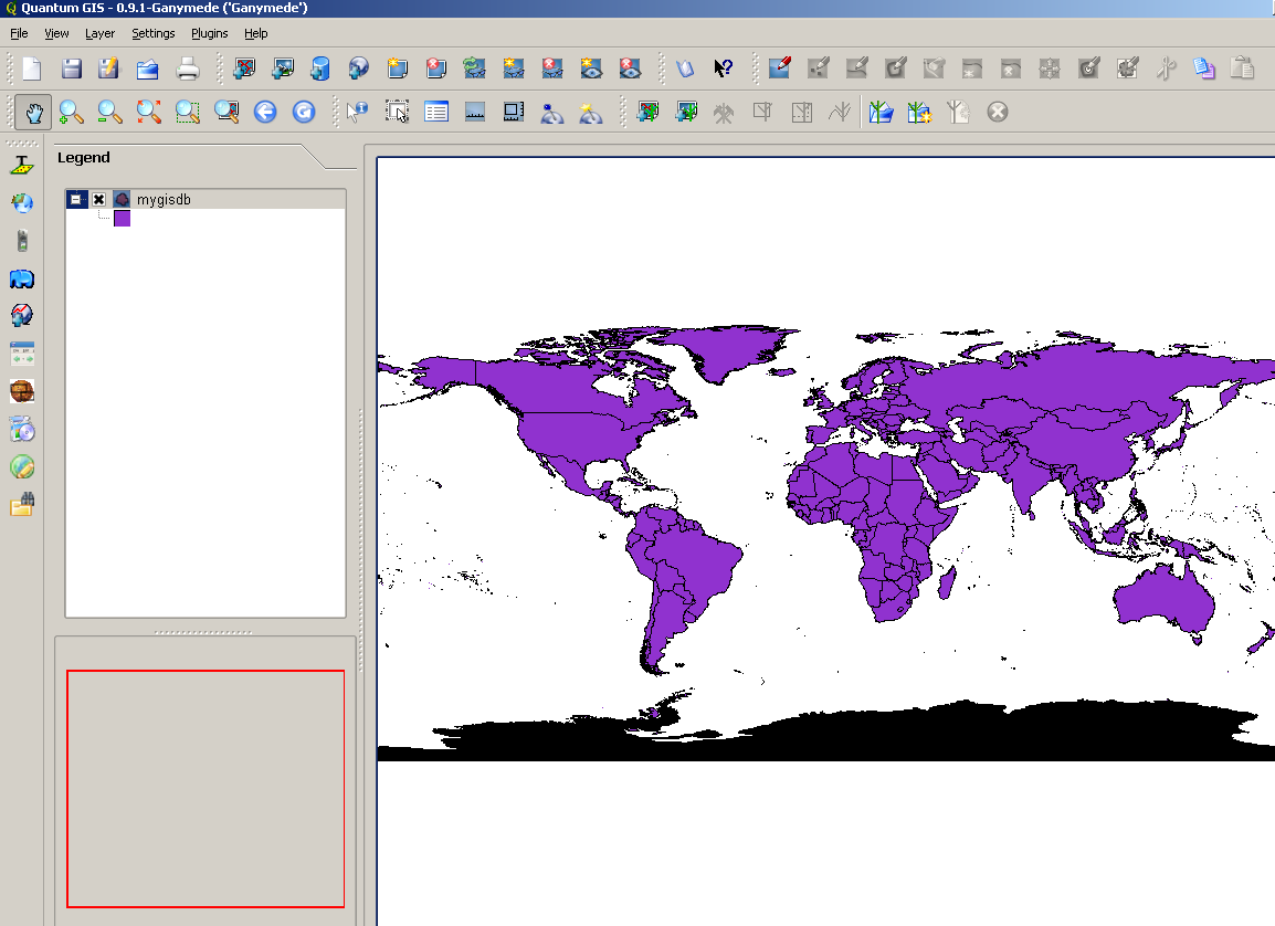
make a postgresql connection, and voila:
and now with mapserver...
mapserv is installed in /usr/lib/cgi-bin/mapserv
download this example mapfile and copy it next to mapserv
change username and password in it
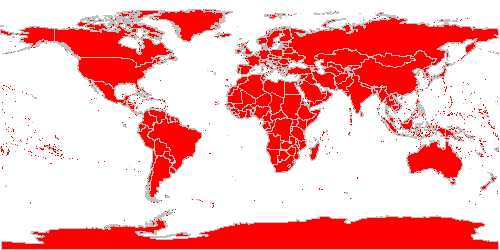
in a browser: to view the capabilities: http://dame/cgi-bin/mapserv?map=world.map&request=getcapabilities&service=wms
or a map: http://yourmachine/cgi-bin/mapserv?map=world.map&mode=browse&layers=all&mode=map
if you see something like: image handling failed... Operation on two geometries with different SRID's, it's because the world import failed to set a srid (projection) for the data
just insert it in the geometry_columns table and update the geometries itself (fire query in pgAdminIII):
update geometry_columns set srid = 4326 where f_table_name = 'world'
select UpdateGeometrySRID('world', 'the_geom', 4326)
and again: http://yourmachine/cgi-bin/mapserv?map=world.map&mode=browse&layers=all&mode=map
happy using linux/mapserver/postgis, sent me an email if it's usefull, I can make an ubuntu version if usefull also ...